
The best way to experience Cinque Terre is along the trails. There is over 120 km of trails along the Cinque Terre coast line with 48 hiking trails available. You will need a special ticket, a Cinque Terre Card, for the following coastal trails: Monterosso - Vernazza, Vernazza - Corniglia and Riomaggiore - Manarola (Via dell'Amore). The trails are open all year around and during winter without fee.
Hiking the Cinque Terre

Hiking trails list
- Monterosso - Vernazza
- Vernazza - Corniglia
- Corniglia - Manarola (via Volastra)
- Manarola - Riomaggiore (Via dell'Amore)
- Manarola - Riomaggiore (via Beccara)
- Riomaggiore - Portovenere
- Levanto - Monterosso
- Footpaths map
Hiking trail Monterosso - Vernazza

Status: OPEN
Difficulty: average
Length: 3,6 km
Duration: 2h
Hiking fee: Yes, Cinque Terre Card
Map: Monterosso - Vernazza hiking trail
Recommended direction: The trail is easier with fewer steps if you walk from Vernazza to Monterosso. If you start in Monterosso the trail begins with a long staircase but you will have great views of Vernazza along the trail.
The footpath is marked in white and red. If you start in Monterosso take the small pedestrian road leading to the Hotel Porto Roca. Some parts are broad and peaceful, and you can always enjoy a wonderful panorama over the sea. The vegetation is very various, you will find evergreen oaks, arboreal heather, broom and juniper. The footpath passes on an antique stone-bridge, which is really worth a picture.
Hiking trail Vernazza - Corniglia
 Status: OPEN
Difficulty: average
Length: 3,5 km
Duration: 1,5h
Hiking fee: Yes, Cinque Terre Card
Map: Vernazza - Corniglia hiking trail
Recommended direction: You can walk this path in both directions, but it is easier to start in Corniglia (100 meters above sea level) by taking the shuttle bus from the train station in Corniglia up to the village. It is a few minutes ride and the ticket is included with a Cinque Terre Card. After visiting Corniglia, with its lovely tiny streets with shops and restaurants, follow the signs to Vernazza. Starting in Corniglia the trail is relatively flat and you will have wonderful views descending towards Vernazza.
Take a break halfway at Prevo, 208 metres above sea level, and the juice bar with fantastic sea views serving delicious lemon granitas.
Hiking trail Corniglia - Manarola (via Volastra)
 Status: OPEN
Difficulty: average/difficult
Length: 5,4 km
Duration: 2,5h
Hiking fee: No
Map: Manarola - Corniglia hiking trail
Recommended direction: The Cinque Terre Card is not required for this trail. The hike can be done in either direction but it is easier to start in Corniglia, as the village is located one hundred meters (330 ft.) above the sea level.
The first part of the hiking trail has a very steep climb. To avoid the steps you can start in Manarola by taking the shuttle bus up to Volastra (10 minutes). Normally there is a bus every hour. The trail starts behind the the small church of Madonna della Salute in Volastra. Now the most beautiful part begins; the walk which will lead you through ancient terraces that decline to the sea, where vines and olives grow thanks to heroic wine makers who produce limited quantities of quality grapes. The vineyard hike is moderately easy and it gives you wonderful views of the Mediterranean and the villages.
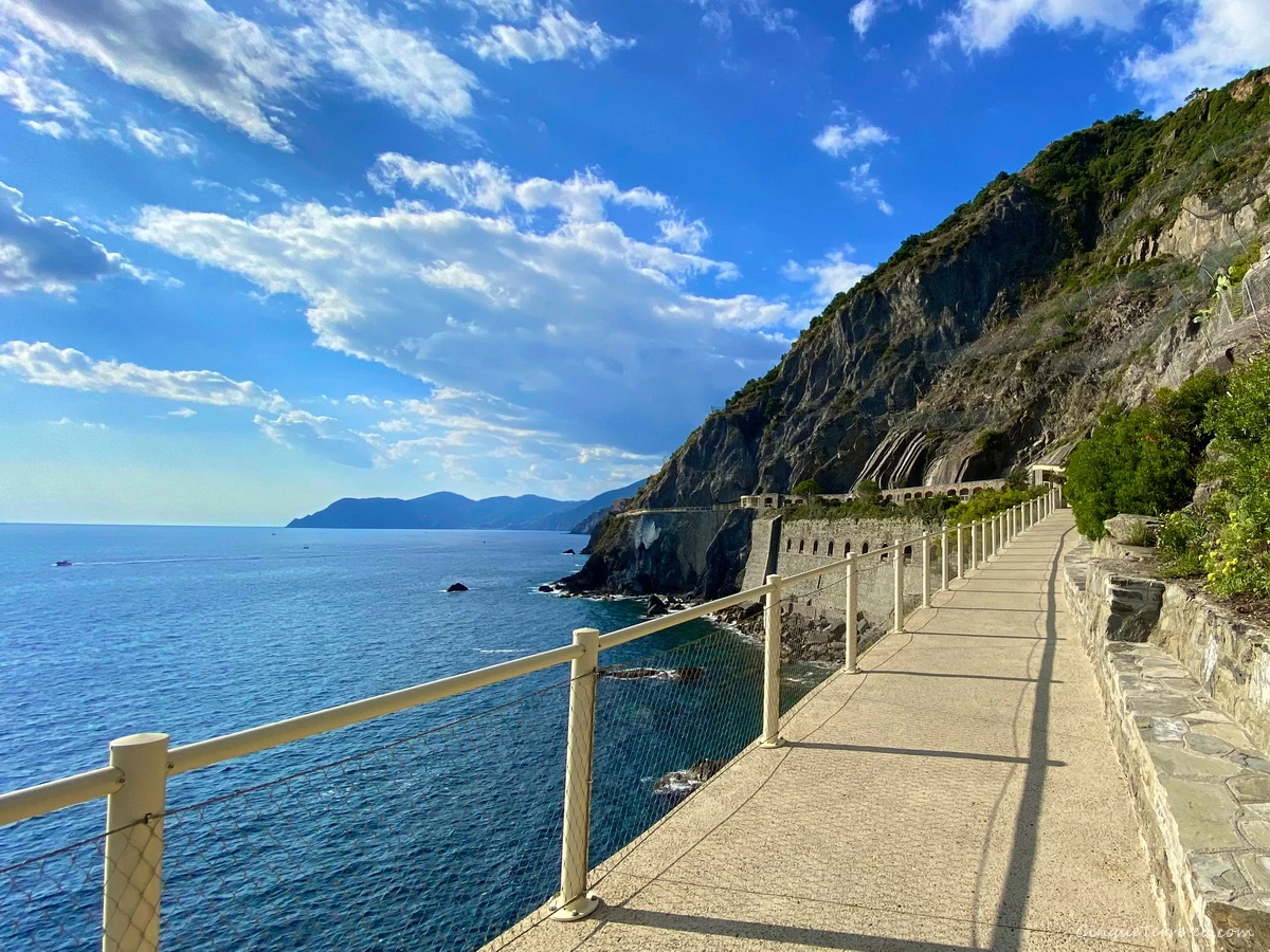
Hiking trail Riomaggiore - Manarola (Via dell'Amore)
 Status: OPEN
Difficulty: easy
Length: 1 km
Duration: 30 minutes
Hiking fee: Yes, Cinque Terre Card + €10
Map: Via dell'Amore
Direction: One-way from Riomaggiore to Manarola.
The famous Via dell’Amore, Lover’s Lane, was reopened for tourists in 2024. Visitors are able to marvel at the gorgeous Ligurian Sea while guides share the story of the Via dell’Amore. The path is accessible with the purchase of a Cinque Terre Treno MS Card or a Cinque Terre Trekking Card, paying a €10 supplement on top of the standard price. If you already have the Cinque Terre Card you can buy the supplement for the Via dell'Amore on-site at the ticket booth near the station In Riomaggiore on the day. Visitors can also buy the Cinque Terre Cards and reserve a time slot for the Via dell'Amore in advance on the website www.viadellamore.info
From March 30 until May 31st, the path is open from 9am until 8pm. From June 1st until October 25, the path is open from 9am until 9.30pm. From October 26 until March 29 the path is open daily from 9am to 6pm.
The Via dell'Amore is the most popular stretch of path of the Cinque Terre, excavated in hard rock, winds along the coast on rocks overhanging the sea. The history of the Via dell'Amore is connected to the construction of the railway between Genoa and La Spezia (1926-28). In order to construct a tunnel between Riomaggiore and Manarola two paths on rocks overhanging the sea were necessary. The path was closed between 2012 and 2024 due to a landslide. An alternative is the trail "Via Beccara" from Manarola to Riomaggiore here below.
Hiking trail Manarola - Riomaggiore (via Beccara)
 Status: OPEN
Difficulty: difficult
Length: 1,8 km
Duration: 1h
Hiking fee: No
Map: Manarola - Riomaggiore hiking trail
Recommended direction: This trail between Manarola and Riomaggiore is an alternative to Via dell'Amore and can be done in either direction. The Cinque Terre Card is not required for this trail. Very good physical condition is required!
The villages of Riomaggiore and Manarola are very close to one another but have a very steep mountain separating them. Half an hour challenging climb due to the number of steep stairs up over the ridge, through a metal gate as you pass across the high point then drop through terraced small-plot grape fields into beautiful town for refreshments. The trail offers panoramic sea views.
Hiking trail Riomaggiore - Portovenere
 Status: OPEN
Difficulty: difficult
Length: 13 km
Duration: 5h
Difference in altitude: 550 m
Hiking fee: No
Map: Riomaggiore - Portovenere hiking trail
Recommended direction: This hike can be done in either direction and the Cinque Terre Card is not required. If you begin in Riomaggiore you will start with a challenging long ascent (45 minutes), but the views are better in this direction. To avoid the climb, there is a possibility in the morning to take the bus up to Telegrafo.
The trail takes you through silent pine forests by a 15th century Sanctuary of Montenero. This is a perfect place for a rest, enjoy the breathtaking panoramic view of the whole coastal line of the Cinque Terre. Ascending to the top of the ridge which separates this coast from La Spezia.
Then starts the most evocative part of the trail, a spectacular cliff-side path with a magnific view over the Mediterranean Sea and the islands of Elba, Capraia, Korsika, Palmaria, Tino and Tinetto. A wooded trail continues along the ridge and emerges at the gulf of La Spezia where we descend to the town of Portovenere. Time for a celebratory drink in the harbour! From Portovenere there is a boat connection back to Levanto and Cinque Terre around 5 pm.
Hiking trail Levanto - Monterosso
 Status: OPEN
Length: 8 km
Duration: 3h
Difficulty: average
Hiking fee: No
Map: Levanto - Monterosso hiking trail
Recommended direction: We recommend starting from Levanto, because from Monterosso the path is very steep at the beginning.
The trail starts on the east end of the beach promenade in Levanto by stairs up to the castle (castello). This path is an old donkey trail and goes through pine forests and Mediterranean vegetation. Nice views over Levanto as you climb the hill. Follow the trail through the forest until you reach the Punta Mesco (semaforo). Follow the path to the right and you will find the ruins of the Chapel of St. Antonio and the old lighthouse. From here breathtaking views of all the five Cinque Terre villages. Many stairs down to Monterosso.
Map of the Cinque Terre footpaths
You can find more maps on Cinque Terre Maps

Hiking trails on Google Maps
Map of the footpath (external links): Monterosso - Vernazza, Vernazza - Corniglia, Corniglia - Volastra - Manarola, Via dell'Amore, Manarola - Beccara - Riomaggiore, Riomaggiore - Portovenere, Levanto - Monterosso.